|
DIAMOND CANYON
The map shows a road going through there, Trapdoor said
with a grin. I used to think I had the
most active curiosity in the world when it came to checking out roads
until I
met Trapdoor.
|
The map shows a dotted line. That means its a trail and this map does not
distinguish between a 4wd trail and a foot trail,: I explained.
Lets check it out.
We got off I-70 at the Cisco exit and headed toward the book
cliffs. After passing through a gate
with a sign instructing us to close it behind us, we came to an intersection
where another sign used to be. An empty
sign post marked the spot. My GPS told
us we were at the right intersection, but there were more roads at that
intersection than there were on the computer map, so we spent the next twenty
minutes driving up to locked gates.
Then Trapdoor noticed tracks going into a wash. A recent rain storm had left huge gulleys
that seemed impassable at first glance.
While Trapdoor and Blue Moon determined ways to repair it, I hike dup
the wsh and found where the road exited it.
Sure enough, the BLM had used the wash to get around private property
for access into Diamond Canyon. I called
Trapdoor and Blue Moon with my radio and told them the wash was the road. They said they had repaired the gulley and
were on the way.
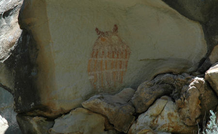
We made it into Diamond Canyon and found ourselves on a very
good dirt road. Along the way, Miss Blue
spotted a pictograph of an owl on one of the rocks in the canyon.
|